
The modern world #8 { Global positioning system (GPS)}.
Chapter 2 - How GPS works ?
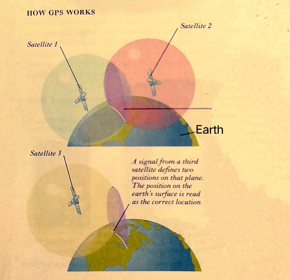
How GPS works
GPS (Global Positioning System) is a satellite-based navigation system that allows users to determine their precise location, speed, and time anywhere on Earth. It consists of a network of satellites in orbit, ground-based control stations, and receivers in devices such as smartphones, cars, and wearable devices. Here's an overview of how GPS works and some common applications in day-to-day life:
Satellite System: GPS satellites orbit the Earth and constantly transmit signals that contain information about their location and the time the signal was transmitted.
GPS Receiver: A GPS receiver in a device, such as a smartphone or car navigation system, receives signals from multiple GPS satellites.
Trilateration: The GPS receiver uses the signals from multiple satellites to calculate the distance between the satellites and the receiver using a method called trilateration. By knowing the distance to multiple satellites, the GPS receiver can determine the user's precise location on Earth.
Positioning and Navigation: Once the GPS receiver has calculated the user's position, it can provide information such as latitude, longitude, altitude, speed, and direction. This information can be used for various applications, including navigation, tracking, mapping, and location-based services.
Navigation: GPS is commonly used for navigation in vehicles, such as cars, ships, and airplanes. GPS navigation systems provide turn-by-turn directions, real-time traffic information, and estimated time of arrival (ETA) to help users reach their destinations efficiently.
Tracking: GPS is used for tracking the movement of objects or people. For example, GPS trackers are used in fleet management to monitor the location and status of vehicles, in logistics to track shipments, in personal devices to track fitness activities, and in pet trackers to locate lost pets.
Mapping: GPS data is used to create digital maps, which are widely used for various purposes, such as navigation, urban planning, and geolocation services. GPS-enabled devices can also record and store tracks or routes, which can be used for outdoor activities like hiking, biking, and running.
Location-Based Services: Many mobile apps and services use GPS to provide location-based information and services. For example, social media apps may use GPS to tag the location of a photo or check-in at a specific place, weather apps may use GPS to provide local weather forecasts, and restaurant apps may use GPS to suggest nearby dining options.
Emergency Services: GPS is used by emergency services, such as police, fire, and ambulance, to locate the precise position of emergency calls and dispatch resources accordingly. GPS can be critical in emergency situations to provide timely assistance.
Timing and Synchronization: GPS signals also contain precise timing information, which is used for applications such as time synchronization for computer networks, financial transactions, and scientific research
Overall, GPS has become an integral part of modern life, with applications ranging from navigation and tracking to mapping and location-based services. Its widespread use has transformed various industries and has become an indispensable tool for many day-to-day activities